
Public Comment Period Open for Southern Maryland Woodlands National Wildlife Refuge
All comments must be received by April 22, 2024
By Mary Hoover, Southern Maryland Conservation Alliance Coordinator
On March 8, 2024, the U.S. Fish and Wildlife Service (Service) released to the public a draft Land Protection Plan/Environmental Assessment for establishing a Southern Maryland Woodlands National Wildlife Refuge, kickstarting a 45-day comment period. This release comes almost a year after the last of three public listening sessions was held at the Calvert Marine Museum in Solomons. A year ago, the Service asked the public to provide feedback on the broad specs of the plan, and the response was overwhelmingly positive. Now, the Service welcomes public comments on the full draft plan, minutiae and all.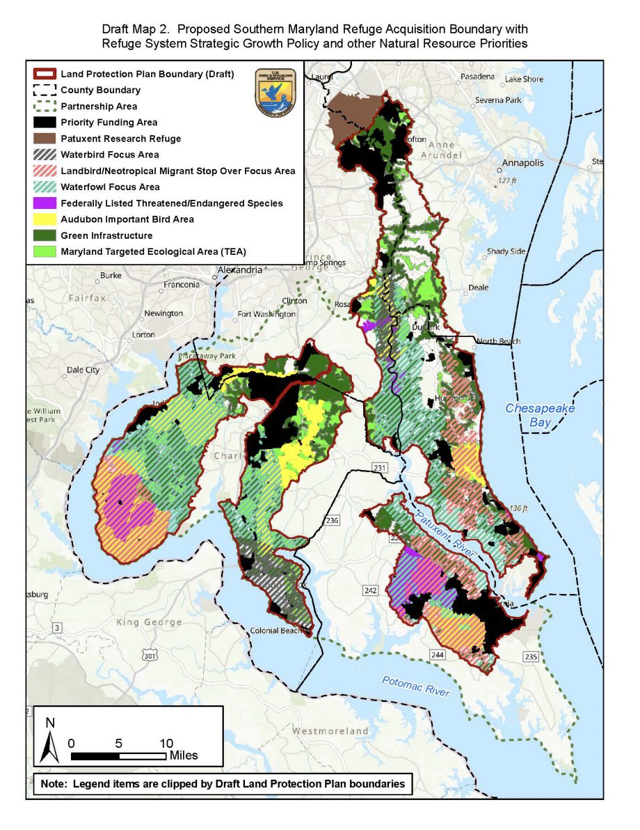
The draft plan and acquisition boundary underwent several iterations before they were approved by the USFWS regional leadership. This time last year, the Service proposed a maximum size of 30,000 acres for the new refuge. As it stands now, the plan proposes the protection of up to 40,000 acres across a 577,420-acre acquisition boundary and over a 30-year timeframe. Although the potential refuge size has increased, the same basic rules apply, namely landowners within the acquisition boundary maintain no obligation to sell or donate interests in their land. The plan, however, presents an opportunity for those who wish to sell or donate interest in their land to do so for a worthy cause.
It is no coincidence that the rollout of the Southern Maryland Woodlands National Wildlife Refuge comes in the wake of newly established, large-scale conservation goals, namely President Biden’s “30×30 initiative” and the Maryland General Assembly’s goal to conserve 40% of the state’s lands by 2040. The draft plan cites these goals in the section titled “Purpose and Need for Action,” and the proposed 40,000 acres of wildlife refuge will be a major boost to both of these goals.
Doing some simple math, we can see just how significant this plan will be for large-scale conservation goals. According to the Maryland Geological Survey, there are approximately 1,243,347 acres of land in the five counties of Southern Maryland. Using data from the Maryland Protected Lands Dashboard, we can calculate that 287,093 acres are already conserved in Southern Maryland, putting the region’s land at 23% protected. The 40,000 acres proposed by this plan would alone cover an additional 3.2% of Southern Maryland’s land. The current percentage (23%) plus the completed refuge percentage (3.2%) would bring Southern Maryland to 26.2% conserved land, not counting all the lands that will be conserved through other means, such as Rural Legacy, recorded open space, forest conservation easements, etc. The imminent refuge funds, on top of all other available resources for land conservation, will greatly propel Southern Maryland toward both 30% and subsequently 40% conservation over the next couple of decades.
More important than numbers, however, are the impacts this plan will have on the innumerable migratory birds, waterfowl, endangered species, and people that occupy this special region. Without protections in place, Southern Maryland’s natural lands are vulnerable to destruction via development, which, however well-intentioned, could destroy the quality of life for those who call this region home, whether they be people, plants, or wildlife. The value of the refuge plan is that it maps out which areas are most critical for wildlife conservation while also establishing a means for protecting these critical areas, and for this reason, we hope you are as excited about this opportunity as we are. If so, please consider taking some time to look over the draft plan (accessible here) and submit any comments or questions to fw5southernmarylandplan@fws.gov.